Product information "
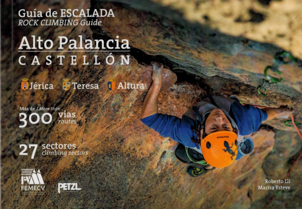
climbing guidebook Guía de escalada Alto Palancia-Castellón"
The experienced climber Roberto Lli, better known as Txentxo, together with Marisa Esteve, has published the book "Guía de Escalada del Alto Palancia", which describes 300 climbing routes and 27 sectors in the municipalities of Jérica, Teresa and Altura. In the climbing guide, Jérica is presented as the center, starting point and reference point for climbing in the area. In the sport climbing areas, climbing is mainly in the french grad 6th. The guide has a modern layout; color photo topos, very good site plans, sufficient and yet concise information about the area and the respective route. Very well done pictograms bring all the really important information to the point and make language skills obsolete. 134 pages Language Spanish / English Edition 2022
This climbing guide describes all multi-pitch routes of Teruel that have been climbed and developed since 1970. A total of 220 classic routes, with graphic topos as well as color photo topos, detailed route descriptions also for the descent, brief information on the equipment of the route, the length and difficulty of the individual pitches, the required belay material as well as the date of the first ascent and the names of the climbers. In sum, these are great routes, whether on freestanding towers or through larger walls. If you like to go classic, Teruel is worth a trip with this guide.480 pagesLanguage SpanishEdition 2023Javier MagallonDesnivel
Cuenca, a huge limestone climbing area with an outstanding density of routes, situated in a fantastically beautiful valley. A total of 1600 routes are described in the guidebook. All the necessary information, such as approach, orientation of the individual sectors, difficulty and length of the tour, wall gradient and child-friendliness are clearly shown in pictograms. The parking lot closest to each sector can be found easily using the QR code. There is also lots and lots of information about the area and its development right at the start of the book. The tabular list of all routes in the various sectors, sorted by number and grade, is very helpful. The routes themselves are clearly illustrated on full-page photo topos.The area is incredibly popular. You will rarely be alone.400 pagesLanguage Spanish / English5th edition 2023J. Yanez, J. OlarteEdiciones Desnivel
This climbing guide presents in its first edition climbing areas in the province of Castellón. Castellón is located between the provinces of Valencia and Tarragona, that is, north of the city of Valencia and south of the city of Barcelona, directly on the Mediterranean Sea.Featured areas: Jérica, Peñas Aragonesas, Tales, Fuentes de Ayodar, Llavalasar, Vallat, El Castellet, La Cantera, Borriol, Orpesa, La Rambla, Atzeneta del Maestrat, Penyagolosa, Barranc de la Guitarra, Sarratella, Culla, Torreblanca, Murs, Torre Badun, Penyíscola, La Pedrera, Morral de l'Angel, Xert, Rosell, MorellaForcall and La Gotera.The guide is reduced to great photos, very good graphic topos, good directions and short and concise descriptions of each location. Of course, there's all the information about the tour itself, such as wall height, difficulty, belay points, tabular and thus clear. The areas are also presented by means of detailed pictograms, so knowledge of Spanish is not obligatory.Single pitches are in the predominant number, but there are also some ingenious multi-pitches described.320 pagesLanguage Spanish1st edition 2010L. Alfonso
The 4th edition of the Chulilla Climbing Guide also gets straight to the point in a very concise manner. It could not be more compact. Pedro Pons puts about 1300 routes on 268 pages. The topos are very easy to read on full-page color photographs of the walls. Everything worth knowing to the individual sectors is explained introductory bilingual (site plans, access as well as approach description, coordinates for the parking lots). All other information is presented in pictogram form (including orientation / exposure, wall slope, climbing style, belay situation, child-friendliness, climbing in rain / wind. Finally, the list of all routes sorted by difficulty - nothing more! Very good and absolutely clear climbing guide for Chulilla!
268 pages Language: Spanish / English Edition 2022 P. Pons
The climbing area that this guide is dedicated to is located in the south of the province of Teruel, more precisely in the Alto Mijares region. At the confluence of the two rivers Rio Mijares River and Rio Palomarejas, the water has formed a deep gorge with limestone walls up to 50 m high on both sides of the river that will delight any climber.The climbing guide is well structured. Brief introduction/information about the area, index for the pictograms used in the guide (including orientation, best time of year, child-friendliness, approach time, duration of sunlight, GPS coordinates) and then the topos are already marked on mostly very good, full-page color photographs. The grade, length and number of fixed belays are given for all routes. The guide is bilingual in Spanish and English throughout.More than 400 well-secured sport climbing routes in beautiful natural surroundings are waiting to be discovered.160 pageslanguage Spanish, Englishedition 2019 Desnivel
Climbing in the Levante north
The climbing guides Levante North and Levante South are classic selection guides, i.e. the climbing areas included are partly described only in extracts. The guide Levante North summarises 16 areas around Valencia. The areas are spread from Culla in the north of Valencia to Gandia in the south, and include such well-known areas as Montanejos, Jérica and Chulilla.
The following areas have also made it into the guide: Oropesa, Serra Engarceran, Els Rosildos, Culla, Araia, Olba, Calles, Chiva, Bunol, Cortes de Pallás, Corbera, Gandía, Pinet.
If you want to concentrate on one of the areas mentioned, you are better off looking for the local guide. However, if you are planning a climbing trip to Valencia and the Costa Blanca and want to look around several areas, this guide is the best choice. The books Levante North and South are in any case a sensible alternative to the overview work Costa Blanca (Rockfax), as the locals profit from the purchase of these works, who develop and partly also redevelop the areas on site with great enthusiasm and financial effort.
The climbing guides are very clearly structured. At the beginning, all areas/sectors are named in an overview and briefly characterised in table form - access time, hours of sunshine, child-friendliness and listing of the number of routes according to difficulty. The individual areas are then shown on map extracts, on which the individual sectors and the corresponding parking facilities are marked. The individual areas are then preceded by further explanations - characteristics of the climbing, length of the routes to be found, slope of the wall, belay situation, exact description of how to get there, GPS data of the parking possibilities, best seasons. And then follow endless topos, marked in different colours (according to the grade) on good colour photographs. Information on the length of the route, the number of fixed belay points and a star rating round off the guide.
358 pages
language spanish, english, french
edition 2019
R. Moulin, J. L. Palao
We use cookies (including third party cookies) to provide you with the best possible service. Some of them are essential, while others help us to improve this website and your experience of it. You have the right to withdraw your consent at any time. You can find more information on Privacy policy.