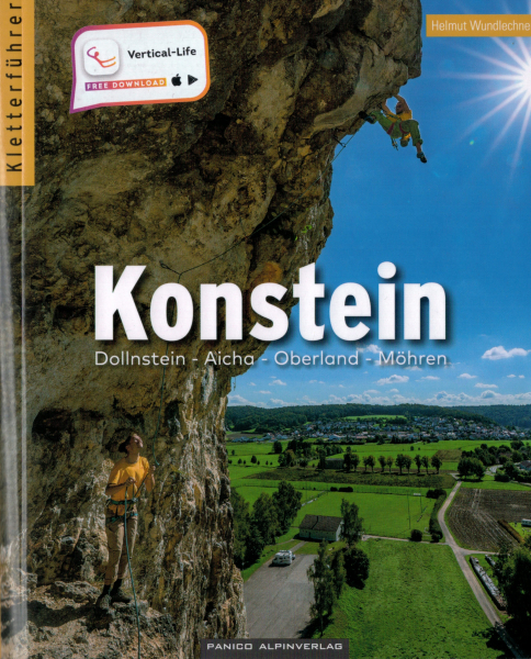
The climbing guide "Southern Franconian Jura" is history. The extensive climbing areas around Regensburg are described in the volume Bavarian Jura is described. The climbing guide Konstein describes all climbing possibilities in Konstein, Wellheim and Dollnstein. It contains additionally the small but fine area of the Möhren quarry. Author Helmut Wundlechner was responsible for the updates and news. All topos were updated, the route comments were extended and brought to the brought to the latest state. Informative overview photos orchestrate the precise access descriptions, detailed maps in combination with QR codes for all starting points and rocks complete the navigation theme. Tedious rock searches are now finally a thing of history. On top: completely new action photos. This makes itchy fingers in the planning already violently in the fingers. Last but not least: the book contains all the necessary descriptions for the environmentally friendly journey with the public transport. Summa summarum a great climbing guide for the venerable cult area. Whether beginner, family, nostalgic, hardcore mover - Konstein has something to offer for everyone. 220 pages Language German Edition 2023
The first volume for the top climbing area of the republic. Completely revised 13th edition - new routes as of June 2024. Whoever thought that there was no more room for improvement was wrong: The new edition has been extended to 608 pages and now documents a proud 6500 routes. Described areas: Leinleitertal, Wiesenttal, Gößweinstein, Püttlachtal, Weihersbachtal, Klumpertal, Ailsbachtal, Paradiestal, Kaiserbachtal, Scheßlitzer areas, Staffelberg, Kleinziegenfelder Tal, Bärental and the Zillertal! The guide comes with a download code for a free application for iOS and Android. You get all the topos contained in the climbing guide in the form of an app for your smartphone free of charge for 3 years. If you have any questions about the app, please contact the Vertical-Life team directly. Frankenjura Band 2 covers the southern part of Frankenjura.
608 pages language german edition 2024 S. Schwertner Panico Alpinverlag
- Warning: Increased shipping costs due to book weighing more than 1kg -
Climbing Guidebook Franken1 / northern Frankenjura Volume 1
The new Band 1 for the northern Frankenjura, published by the GEBRO Verlag describes in 4rd edition on 479 crags 6750 routes. Handdrawn, 3-dimensional and detailed topos, each topo a small work of art. Wether its an overhang, a slab or an arête - these topos give already an idea of the shapes of the cliffs and the course of the routes.
Including a selection guide › The most worthwhile crags are highlighted by red colour (tips for crags)
Big, clear, artful handdrawn drawings of the crags › Finally topos which give an idea of the shape of the rock and the course of the routes, also for the classics.
Smart design with symbols and many details
User-friendly surface › Quick search for your favourite crag! (also index of crags)
GPS-coordinates, exact access information and detailed access maps with distances › No more unwanted surprises on access and approach!
768 pages and a cover with flaps as perfect bookmarks
479 crags with more than 900 single topos and 6750 routes
Clear crag-info-tables with route statistics (including height of the crag, orientation, crag base vegetation, access time and child friendliness)
Stars for all cliffs
Tips for worthwhile and extremely worthwhile routes
Info about developers and first ascents
Restaurant-tips
Charging stations for electric cars
Totally bilingual German/English
incl. crags:
Tiefenellern • Frankendorf • Leinleitertal • Wiesenttal • Gößweinstein • Püttlachtal • Weihersbachtal • Klumpertal • Mariental • Ailsbachtal • Aufseßtal • Krögelstein • Paradiestal • Würgau • Stübig • Wattendorf • Ziegenfelder Tal • Bärental • Zillertal
768 pages Language: german, english Edition 2023
Ulrich und Harald Röker Gebro Verlag
- Warning: Increased shipping costs due to book weighing more than 1kg -
Completely revised 14th edition - new routes as of April 2024. The second volume has also gained a few more pages: There are now an impressive 608, documenting the incredible number of 6900 routes. Together with Volume 1, this means that there are now well over 1,200 pages and a good 13.400 routes! Of course, the GPS coordinates for all the crags are listed, as well as all the associated parking or starting points. After all, you want to climb and not crawl around in the undergrowth looking for rocks. And the quality is of course as you are used to from Panico: completely four-coloured, colour-coded route lines and much more. Described areas: Walberla, Trubachtal, Betzensteiner area, Spieser area, Schnaittacher area, Pegnitztal, Krottenseer Forst, Hirschbachtal, Königsteiner area, Lehental, Högenbachtal, Förrenbachtal and the Lauterbachtal! The guide comes with a download code for a free application for iOS and Android. You get all the topos contained in the climbing guide in the form of an app for your smartphone free of charge for 3 years. If you have any questions about the app, please contact the Vertical-Life team directly. 608 pages language german edition 2024
S. Schwertner Panico Alpinverlag
- Warning: Increased shipping costs due to book weighing more than 1kg -
The climbing guide for the Southern Franconian Jura. Sport climbing in the Franconian Jura.Until the follow-up volume for the Konstein area is available, the (paid) Vertical Life app will help you find your climbing destinations in Dollnstein and Konstein.The climbing guidebook "Südlicher Frankenjura" is history. The extensive climbing areas around Regensburg are now described in the Bavarian Jura volume. The removal of the crags between Eichstätt, Dollnstein and Wellheim into an independent climbing guide Konstein (to be published in spring 2023) creates the much needed space for numerous novelties between Altmühl and Naab.The now available climbing guide "Bavarian Jura" describes on 480 pages almost 100 destinations with a total of about 1700 routes, the area of climbing destinations is significantly expanded: In the Altmühltal, previously unpublished crags near Dietfurt are described. The chapter Labertal is enlarged beside smaller extensions up to the area Velburg. From there - south of the Hohenfels military training area - the connection is made to newly developed crags between Raitenbuch and Kallmünz. Finally, in the Naab Valley, two classic climbing destinations are presented for the first time.Thanks to Eberhard Zieglmeier's most intensive efforts and his comprehensive local knowledge, there are updates for all objectives. Almost all topos have been revised and supplemented, the routes characterized in comments and access descriptions updated. The fact that everything has been rounded off with a new illustration makes especially want to climb.In addition to the area maps for a quick overview, our proven detailed maps also show the location of the rocks, as well as their access. They are also provided throughout with QR codes to comfortably get to the respective parking lot, as well as with the descriptions for environmentally friendly travel by public transport - so everyone should find to their vertical desired destination.Even if the areas around Regensburg are no longer as popular internationally as they once were, the high quality of the routes and the scenic ambience are second to none. The climbing guide "Bavarian Jura" includes a short historical outline of the climbing history of the Altmühltal and so-called "spots" on archaeological, architectural features and - last but not least - flora & fauna worth protecting.Let yourself be inspired and plan your next climbing trip true to the motto "Why go far, ...". The Bavarian Jura has more to offer than "canal in the back"!The guide comes with a download code for a free, three-year app for iOS and Android. If you have any questions about the app, please contact the Vertical-Life team directly.Contents: Altmühltal, Donaudurchbruch, Labertal, Naabtal and side valleys480 pagesLanguage GermanEdition 2022E. ZieglmeierPanico Alpine Publishing
The new edition of Franken 2 has just been published, here are the hard facts:Described areas of the southern part of the northern Franconian Jura:Unteres Trubachtal - Walberla - Todsfelder Tal - Oberes Trubachtal - Bärnfels - Betzenstein - Spies - Plech - Sittenbachtal - Pegnitz - Krottenseer Forst - Königstein - Neuhaus - Hartenstein - Pegnitztal - Hirschbachtal - Etzelbachtal - Förrenbachtal - Högenbachtal - Lauterachtal - Forellenbachtal - NeumarktThe 4th edition is extended by:+ 64 pages + 43 areas + 777 routesAlso new:+ QR codes for navigation to the parking lot + Links and QR codes to our update page430 crags with over 1100 individual topos and over 7570 routesIncluding integrated selection guide ' The best crags are highlighted in red (crag tips)Large, clear, artistic and plastic rock drawings ' Finally an idea of rock shape and route courses based on the topos, even for classics!Clever layout with symbols and lots of detailsUser-friendly interface ' Quickly find your favorite crag! (also index of all rocks)GPS coordinates, precise access descriptions and detailed approach sketches with distances ' No more unpleasant adventures on the approach and ascent!New: QR codes for navigation to the parking lotNew: Dynamic interaction with updates on our Internet pages: e.g. also direct links and QR codes for retrieving updates on rocks in the development phase832 pages with gatefold cover as an ideal bookmarkClear crag information tables with route statistics (including wall height, orientation, wall base vegetation, access time, child-friendliness)Star rating of all cragsTips on rewarding and particularly rewarding routesInformation on developers and first-time climbersCatering tipsCharging stations for electric carsLots of great action and landscape picturesBilingual German/English throughout832 pagesLanguage German / EnglishEdition 2024Ulrich and Harald RökerGebro Publishing House- Attention: increased shipping costs due to book weight of more than 1kg -
Munich is considered the mountaineering capital of Germany. On fine days, you can see from the Olympiaberg to the Zugspitze. The climbing areas on the edge of the Alps and in the Altmühltal valley are home to the Munich climbing scene and can often be reached in 1-2 hours from Munich Central Station. An exclusive selection has been made for this climbing guide from the huge range of climbing opportunities, for which Panico has six independent area guides. It is limited to the crags that are easily accessible by public transport. So if you like collecting climate-friendly Ecopoints, this book is perfect for you and will guide you to the starting point as if on rails and to the crag with the downloadable GPX tracks. The clearly laid out map sections and the coordinates of the starting points will also help drivers to find their destination.The walls and routes are illustrated with easy-to-read photo topos, and there are graphic topos where there is too much shrubbery blocking the view. A concise route list with difficulty and route length provides the most important data to experience many great climbing days on the rocks around Munich with this book. But that's not all. For bad weather days - or if you simply want to train without a long journey and approach - all the larger climbing and bouldering gyms in the Munich public transport network (MVV) are presented in a separate chapter. 224 pagesLanguage germanEdition 2024M. Herzberger, M. Stadler, L. Müller, M. StannartzPanico Alpinverlag
The original climbing guide Out of Rosenheim has since become a classic, growing from a rather slim first edition in 2000 with only 120 pages to the current edition in 2025 with 520 pages. A very active scene ensures the constant development of climbing opportunities in the region. Volume 2 of the three-part series describes the climbing opportunities in the Bavarian Prealps between Reichenhall and Bad Tölz—in other words, all areas immediately to the right and left of the Inn between Rosenheim and Kufstein. In addition, it covers the most rewarding climbing gardens and sport climbing areas in the Zahmer and Wilder Kaiser, including the famous Schleierwasserfall and Achleiten.WendelsteingebietWendelsteinLöchelwandKaserer WandAmeisenwandlGschwandtMitteralmBixlwandBlockwelt SudelfeldRosengassenbrückeUnterinntal WestBiberFlintsbachWagnerwandDruidenwandlKlammwandLuegsteinwandWeberwandSchloßbergRamserer StoaBrünnsteinUnterinntal OstLamprechtsfelsenNicht enthalten: WolfschluchtKundl und BackofenRock CityWeigend-WallGodzillawandHöllwandSpitzsteinwandKlettergarten SebiKufsteinMorsbachGeisterschmiedwandSparchenVorderkaiserfeldenSteingrubenschneidWilder KaiserAchleitenGaudeamushütteSchleierwasserfallFritz-Pflaum-HütteStripsenjoch512 pageslanguage germanedition 2025M. StadlerPanico Alpinverlag
We use cookies (including third party cookies) to provide you with the best possible service. Some of them are essential, while others help us to improve this website and your experience of it. You have the right to withdraw your consent at any time. You can find more information on Privacy policy.